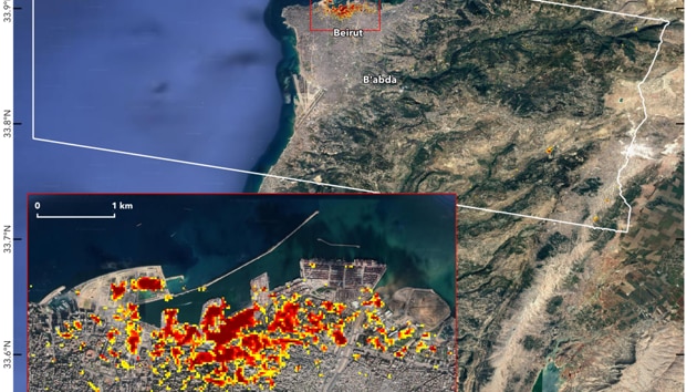
On the map, dark red pixels – like those present at and around Port Beirut – represent the worst damage.
Le hindustantimes.com | Edited by Anubha Rohatgi | Hindustan Times, New Delhi
UPDATE ON AUG 11, 2020 08:10 AM IST
NASA has used data coming from a satellite to quantify the extent of the damage caused by the August 4 explosion in Beirut that killed at least 163 people.
The Advnaced Rapid Imaging and Analysis (ARIA) team of the American space agency, in collaboration with the Earth Observatory in Singapore, analyzed synthetic aperture radar data that came from a satellite to produce the map.
“Maps like this one can help identify areas of severe damage where people may need help,” NASA said in a statement.
On the map, dark red pixels – like those present at and around Port Beirut – represent the worst damage. Areas in orange are largely damaged and areas in yellow appear to have done less damage. Each colored pixel represents an area of 30 meters (33 yards).
The map contains modified Copernicus Sentinel data processed by the European Space Agency (ESA).
The devastation caused by the explosion was also captured in many satellite images.
The SkySat spacecraft, operated by the company Planet San Francisco, captured detailed images of the port of Beirut both before and after the explosion. Planet posted the photos on Twitter a day after the explosion.
Colorado-based space technology company Maxar also shared before and after images from the Beirut explosion.
The explosion in the Lebanese capital last week occurred at a warehouse of what authorities said contained more than 2,000 tons of ammonium nitrate, injuring more than 6,000 people and causing widespread destruction.

Close